


Interactive Geography
Overview
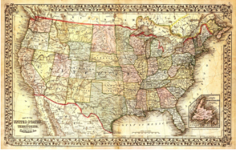
Sheppard Software has interactive, fun geography games. There are eight different levels of difficulty to choose from based on skill level. You can focus on the US and their capitals or learn more about the geographic regions of the US by clicking on them.
In fourth grade social studies, students focus on the regions of the United States, along with the physical characteristics, including the Great Lakes. They also learn how the US is divided into regions, along with learning the states and their capitals.
Learning Objectives
Students will:
- Be able to learn the geographic regions of the United States.
- Be able to identify all 50 of the US states.
- Be able to identify the capital of each US state.
Vocabulary
Vocabulary Words:
- Geographic Region: A geographic region are areas that are divided by physical characteristics.
Pre-planning
To prepare for this lesson:
-
Go to the Sheppard Software website.
-
At the very top click on the USA. This will bring up capitals, states, and landscapes. Students can click on “tutorial” which will take them through all the states and their names, capitals, etc.
-
There are different levels to learn the content. Depending on the level of the student, you can tell each student what level to start on or simply have them all start at the beginner level.
-
Teachers can get an idea of the tutorials by watching this short video clip, Learn the 50 USA States! - Geography Map Video and Games.
Accommodations
See Accommodations Page and Charts on the 21things4students.net site in the Teacher Resources.
Steps
Directions for this activity:
- The teacher can use Screencastify to show students a tutorial on how to get to the website and play the games listed above. Or, feel free to just model for them what to do.
- The students will go to the website http://www.sheppardsoftware.com/
- The students will click on USA from the top bar on the left.
- Depending on what you want the students to focus on, they will click on either the capital tutorial, states, or landscapes.
- After watching the tutorial, students can start at the beginner level to play. On the left side, there are controls where you can have the students only select a certain region to study. This is perfect considering we usually only teach students one region at a time. The game keeps score, percentage correct, and time at the bottom of the screen. This makes it much more fun and engaging for the students.
- If you are learning one region at a time, students can then use paper and draw out that region using colored pencils to show the physical characteristics. They can keep adding to this every time you add in a new region.
Assessment Options
Different options for assessing the students:
- Observations
- Check for understanding by walking around and seeing what their score or percentage right is.
-
Print out a map and have students fill it in as an exit ticket at the end of the period to see how well they learned that region.
MITECS Competencies & ISTE Standards
MITECS: Michigan adopted the "ISTE Standards for Students" called MITECS (Michigan Integrated Technology Competencies for Students) in 2018.
Knowledge Constructor
3a. Students plan and employ effective research strategies to locate information and other resources for their intellectual or creative pursuits.
3c. Students curate information from digital resources using a variety of tools and methods to create collections of artifacts that demonstrate meaningful connections or conclusions.
Devices and Resources
Device: PC, Chromebook, Mac, iPad
Browser: Chrome, Safari, Firefox, Edge, ALL
App, Extension, or Add-on:
Websites:
Learn the 50 States Video
CONTENT AREA RESOURCES
Integrated Arts
Students can draw a map of the United States and divide it into regions, using colored pencils to show the physical characteristics of each region.
Social Studies
- The students can identify the states and capitals within the United States.
- The students can identify the regions that the United States is divided into.
Credits
This task card was created by Dawn Phillips, Wyoming Public Schools. August 2019. Updated January 2022.